Photo Credit: from the collection of Vivian Yess Wadlin
Poughkeepsie’s South Road: Its Past and Future
Mary M. Flad
Just at the south edge of the City of Poughkeepsie are a number of properties of social and architectural significance. All of them are close to “South Road,” the traditional name given in the nineteenth and early-twentieth centuries to what is now better known as Route 9; some are in the Town of Poughkeepsie and some within the city limits. Each has its own distinct historical past. Early in the last decade, a discussion began about linking them as part of a “Greenway Trail,” which could then be linked to other trails and to the “transportation hub” at the Poughkeepsie railroad station. The locations, buildings, and properties that have been discussed as part of the “South Road heritage area” include the following:
• Locust Grove: the home of Samuel F.B. Morse for the last twenty-five years of his life, and one of America’s first National Historic Landmarks;
• The Poughkeepsie Spring or “Apokeepsing” (shown on some early maps with the Dutch name “Rust Plaets”): tradition holds that it was an original
settlement location of newly arrived European immigrants to the area;
• Maple Grove historic site: a “Hudson River Bracketed” country villa built in 1850;
• Poughkeepsie Rural Cemetery: established in the 1850s, when church graveyards within the city limits were no longer used for burials;
• Springside Landscape Restoration: originally the site of Matthew Vassar’s summer home, a privately maintained National Historic Landmark that is open to the public.
Because these properties are the small vestige remaining of the cultural landscape of the area fifty or 100 years ago, they are of particular interest.
The Poughkeepsie urban area has a long settlement history. The presence of European settlers is documented more than 320 years ago, while Henry Hudson’s explorations along the Hudson River took place several decades earlier. Tradition says that the original settlement was named with a mutilated version of an Indian name for the locale, meaning “little reed hut by the falling-water place.” 1 What is now the City of Poughkeepsie remains at the center of this place on the east side of the river, but over the last four centuries there has been constant change, and this process continues.
The north-south roadway now known as Route 9 follows the track of a road that dates from the time of the earliest European settlers, in all likelihood following the pathway defined even earlier by Indian trails; but in reality the main “highway” in this era was the Hudson River. Transportation of goods and passengers took place most easily and efficiently on the water. The road north from Broadway in New York City was known as the King’s Highway (or the Queen’s, during the reign of Queen Anne) until the time of independence, and then became the Albany Post Road. By the latter part of the eighteenth century, the Albany Post Road (quite literally the roadway along which the mail delivery traveled) was an important connector, linking the settlements and farms along its route, paralleling the river but generally on higher land a mile or two (or sometimes more) to the east. The Dutchess County volume of the American Guide series, prepared by the Federal Writers’ Project in the 1930s 2, provides a vivid picture of commerce and activity along the highway in this era:
Stagecoaches began running regularly over the Post Road from New York to Albany in 1786. The necessity of changing horses every 10 or 20 miles led to the establishment of the stage houses. In the hamlets these taverns were the centers of community life; travelers enlivened discussions with the latest news, and liquor flowed freely. De Chastellux, traveling twice through Dutchess, in 1780 and 1782, writes that he found taverns enough, but few sufficiently unoccupied to accommodate him. It is believed that by 1800 there were nine taverns in Rhinebeck alone.3
A few of the milestones from the era of the Albany Post Road can still be spotted along the edge of Route 9. The placement of these stones was initiated by Benjamin Franklin when he served in the role of Joint Postmaster General in the colonial period, then as the first Postmaster General of the new nation appointed by the Second Continental Congress in 1775. Taverns and places of accommodation continue to be in abundant supply, although quite different in scale and design from what could be found along the road in the late eighteenth century.
A 1799 map of Poughkeepsie reproduced in Platt’s History of Poughkeepsie4 shows ten houses along the stretch of the Albany Post Road south of what is now the city boundary, reaching down two miles to the Spackenkill area, all of them on the east side of the road, and most of them with the family name Freer associated with them. Small farms dotted the landscape, prosperous from growing wheat to meet the demands of New York City to the south. When the Erie Canal was completed in the 1820s, suddenly grain was coming from larger farms further west and undercutting the prices at which Dutchess County’s farmers had been selling. At the same time, a wheat rust blight attacked crops in the region, and the local agricultural economy weakened. But small-scale farming and dairy herds continued to be a dominant land use in the area up into the mid-twentieth century.
The road itself was improved gradually, from the rutted carriage path of early days to a better-maintained dirt road, and then to a paved surface with a trolley track running along its edge. Some of the properties along the road progressed from being “working farms” into “country homes” with more prosperous owners, many of them also claiming another residence in New York City or within the City of Poughkeepsie. This was true particularly in the years immediately after train service reached Poughkeepsie in 1850. Two of the houses in the South Road heritage area exemplify this trend.
Samuel F.B. Morse, a prominent New Yorker, purchased an old farmhouse and surrounding property in 1847. He named it Locust Grove, and hired the well-known architect Alexander Jackson Davis to redesign the house to meet his needs and taste. Morse was widely known as the inventor of the telegraph, as well as an artist and a founder of the National Academy of Design.5 He made his home primarily at Locust Grove until his death in 1872, occasionally involving himself in social causes and politics (once he ran for Mayor of New York City, another time for Congress), as well as local philanthropy. In the twentieth century, the property was owned by Annette Innis Young; upon her death it became a house museum and historic site memorializing Morse’s career.
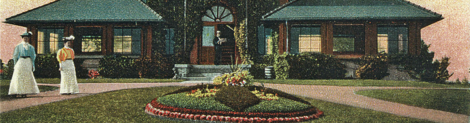
Maple Grove, another country house, was built by New York City banker Charles A. Macy in 1850. It changed hands more than once in the next two decades, and then in 1870 was purchased by Adolphus Hamilton, a friend of Morse’s who had been living in New York City, and who earlier had been in business in New Orleans until the Civil War threw his life there into turmoil. The Hamilton family and their descendants, the Kinkeads, owned and lived at Maple Grove for almost 120 years. In 1987 the estate of Elise Kinkead deeded the property to the St. Simeon Foundation, to facilitate the expansion of housing for the elderly, which had been built on adjacent land. Maple Grove and Locust Grove are the only remaining “country estates” of the number that had been built in the immediate area in the mid-nineteenth century, when the arrival of the railroad at Poughkeepsie made it seem the perfect location for “a house in the country.”
Springside, the “summer home” of Matthew Vassar, also dates from about 1850, when the wealthy owner of a local brewery (and later founder of Vassar College) purchased a piece of farmland about two miles from his home in the City of Poughkeepsie and hired the renowned landscape designer Andrew Jackson Downing to lay out a plan for the property and oversee its development.6 Although Downing died tragically at the age of thirty-seven in 1852, the scheme that he laid out was substantially executed over the next several years. Downing described his vision for Springside as “a place which is a combination of the park-like and pastoral landscape” with “sylvan and pastoral beauty.” 7 Although a private estate, Springside was a popular site of visitation for tourists and travelers, and it remained so up until 1864, when Vassar moved there permanently upon retirement to spend the last four years of his life. Springside was designated a National Historic Landmark in 1969. The property was deeded to Springside Landscape Restoration in 1990; in the years since, the non-profit organization has been working on preserving and restoring the site, and developing and maintaining its walking trails for visitors.
The Poughkeepsie Rural Cemetery, immediately across Route 9 from Maple Grove and within about a half-mile of both Locust Grove and Springside, also dates from the same period as these neighboring properties. The development of “rural cemeteries,” beginning with Mount Auburn Cemetery outside of Boston in 1831, became an essential cultural resource for an urban area. A.J. Downing himself referred to them as “the first really elegant public gardens or promenades formed in this country.” 8 The Sunday visit to the rural cemetery, combining a picnic, the enjoyment of the beauty of the park-like landscape, and then tending of the gravesites of departed family members, became a popular recreational activity in every city that had this amenity. The Poughkeepsie Rural Cemetery was established in 1852. Its curving drives, beautiful and varied trees, and ornately designed tombstones and burial vaults are typical of the rural cemeteries laid out across the country in the mid-nineteenth century. Just inside the gate, an elegant round brick structure (which is still standing) served as a shelter for those waiting for the trolley, giving evidence to the popularity of the cemetery as a site of visitation.
The Poughkeepsie Spring emerges from the earth off Sharon Drive in the Town of Poughkeepsie, several hundred feet northeast of the road’s intersection with Route 9, in an overgrown thicket of vines, saplings, and poison ivy. From there a small stream meanders northward through an adjoining property, and then through the open meadow at the western edge of Maple Grove, past clumps of cat-tails and other wetland plants. Close to the northern edge of Maple Grove, the stream crosses Route 9 through a culvert and then makes its way down through the Poughkeepsie Rural Cemetery to the Hudson River. It is a very small water body, and would likely be totally ignored were it not for the legends linking it to Poughkeepsie’s early settlement history. Early maps indicate that a Livingston house and mill were located close to the stream’s entry into the Hudson.
Until the last few decades, the route of the Albany Post Road north into Poughkeepsie, once it reached the city limits, followed South Avenue and Market Street into the center of town, and then continued north on Washington Street until it was again outside the city and proceeding northward toward Albany. This remained the route of the highway once it was renamed Route 9 in the 1920s, when the scheme for numbering highways was adopted—odd numbers running north/south, even ones east/west. As automotive traffic replaced horses, stagecoaches, and trolleys, the nature of the roadway changed as well. Between 1940 and 1980, the major transformation of land use and the local economy—the building of the IBM main plant, the development of strip malls and shopping centers, the widening of Route 9 to a multi-lane highway, the laying out of an arterial roadway (now sometimes referred to as the “NASCAR speedway”) to bypass the city streets—all combine to make the historic landscape of South Road almost unrecognizable. This was the challenging setting in which discussion about developing a “South Road Heritage Trail” began in 2004. With the active involvement of volunteers and staff from Springside, Maple Grove, and Locust Grove, and with input from the Poughkeepsie Rural Cemetery and Central Hudson (whose headquarters are another neighboring property), an application was submitted for planning funds from the New York State Greenway program, with Locust Grove acting as “lead agency” for the group. Stefan Yarabek, landscape architect of Hudson & Pacific Designs, was commissioned to prepare a conceptual plan for linking the trail resources of the South Road properties that could be drawn together to grapple with the daunting challenge of more than 53,000 vehicles a day racing through the middle of it.
The volume of traffic on a highway like Route 9, which only grows from year to year, can make it seem pointless to develop a plan for walking access through the same area. However, the unusual collection of resources in the South Road heritage area, and the potential for a collaborative initiative to enhance their accessibility, made it possible for the planning phase of work to move forward. Locust Grove itself maintains about three miles of walking trails on its 100-acre property, and acquisition of three additional parcels of land in 2005, 2006, and 2007—previously parts of the Edgehill and Southwood estates—has expanded its potential trail resources. Former carriage paths are being incorporated into the trail system. The Poughkeepsie Rural Cemetery has always been available for walking through its 165 acres of trees, lawns, and monuments. Springside Landscape Restoration’s efforts over the last forty years to restore the historic landscape on its twenty-two-acre site and to improve the trails through it have drawn an increasing number of visitors. Although the Maple Grove Restoration Project has concentrated to date on the restoration of the main house on the property, walking tours during Watershed Awareness Month in 2009 and 2010, going from the house down through the allee of maple trees, to the meadow where the Poughkeepsie Spring’s stream flows, have drawn dozens of interested visitors. It is hoped that, in the next few years, it will be possible to develop a disabilities accessible trail loop on the Maple Grove land that would be part of the South Road Heritage Trail.
The Hudson & Pacific Designs’ study and master plan laid out the following delineation for the South Road Heritage Trail:
• A route connecting the South Road properties
• Suggested pedestrian crossing points across Route 9
• Location of available parking areas along the proposed route
• A recommended walking path from the South Road properties, on through the historic district (Academy Street and Garfield Place) of nineteenthcentury houses in the city, past the Soldiers’ Fountain and the Adriance Memorial Library on Market Street, and down Main Street to the Poughkeepsie railroad station
• Access to bus routes and bus stops along the proposed route
Since the completion of the Hudson & Pacific study, Locust Grove has had further discussions with the New York State Department of Transportation about installing walk lights and road markings at appropriate locations (particularly the Sharon Drive intersection with Route 9) to provide a safe walking environment for visitors. Locust Grove has made application for such improvements to be installed the next time DOT work is undertaken on this stretch of Route 9.
The existence of a Master Plan for the South Road Heritage Trail provides a foundation to build on for developing another walking-trail resource for the Poughkeepsie area. In 2009, Walkway Over the Hudson opened on the span of the old Poughkeepsie-Highland Railroad Bridge, and sections of the Dutchess Rail-Trail have come into use, from Morgan Lake toward the southeast. The plan for a walking trail along the Fall Kill, reaching from the banks of the Hudson at Upper Landing (the site of two eighteenth-century buildings), through the city, and on northeast toward Val-Kill, the Eleanor Roosevelt Historic Site in Hyde Park, continues to evolve. Walkway Over the Hudson has taken close to twenty years to come into actuality; the Fall Kill trail plans have been underway for about a decade, and the rail trail for about the same period. During that span of time, interest in walking paths and pedestrian recreation has grown steadily.
The South Road Heritage Trail exists only on paper as of 2010, but it has gone through a significant planning process, including public meetings and review. Most of the trail network is already in place; all that is needed is the connecting links, the trail loop within the Maple Grove property, and the endorsement of it as a Greenway trail by public-sector entities, including local governments (the Town and City of Poughkeepsie) for it to become a reality. This may take another five or ten years. But that is only a short period of time in the continuing transformation of South Road.
For more information about the properties in the South Road Heritage Area, visit the following Web sites: Locust Grove, www.lgny.org; Maple Grove historic site, www.maplegroveny.org; Poughkeepsie Rural Cemetery, www.poughkeepsieruralcemetery.com; and Springside Landscape Restoration, www.springsidelandmark.org.
Endnotes
1. Helen Wilkinson Reynolds, Poughkeepsie: the Origin and Meaning of the Word. Poughkeepsie: 1924.
2. American Guide Series. (Compiled by the Workers of the Dutchess County Unit, Federal Writers’ Project, of the Works Progress Administration in the State of New York. Dutchess County. Philadelphia: William Penn Association, 1937.
3. Op.cit., p.15.
4. Edmund Platt. The Eagle’s History of Poughkeepsie, from the Earliest Settlements, 1683 to 1905. Poughkeepsie: Dutchess County Historical Society, 1987, p.71.
5. Carleton Mabee, “Morse’s Genius Sparks a Revolution,” in The Hudson Valley: Our Heritage, Our Future. Poughkeepsie: Poughkeepsie Journal, 2000, p.152-53.
6. Harvey K. Flad. “Matthew Vassar’s Springside: ‘the hand of Art, when guided by Taste,’“ in Prophet With Honor: the Career of Andrew Jackson Downing 1815-1852. Washington, DC: Dumbarton Oaks, 1989, p.219ff.
7. Op.cit., p.242.
8. David Schuyler. Apostle of Taste: Andrew Jackson Downing 1815-1872. Baltimore: Johns Hopkins